Interactive World Maps — The Responsive Interactive Maps Plugin
Pro Items
Developer: cmoreira
Version: 2.5 report oudated
Updated: 23 April 2024
File status: Original
File name: codecanyon-interactive-world-maps-2.5.zip

interactive world maps 2.5 The Responsive Maps Plugin

Create as many maps as you want, with interactive and colored markers, continents, countries or regions read more
2 users like this.
You don't have a valid membership to download this item. Purchase one here.

Other items in collection

Best Addon for Elementor WordPress Plugin with 50+ Most Popular Elements that need your everyday

The Boosted Elements plugin adds additional page builder elements to the free Elementor page builder

Cornerstone is a 100 front end WordPress page builder that will change the way you

WooCommerce Photo Review helps you increase social proof which will lead to increase sales Send

WooCommerce Lookbook allows you to create realistic lookbooks of your products Your customers can buy

Hang on. We're loading...

More items you'd like to see

Extensive Store Locator Feature with Custom Styles and Captions

Custom Interactive Map WordPress Plugin

advanced-google-maps-plugin-for-wordpress
Create unlimited locations maps and display Google Maps

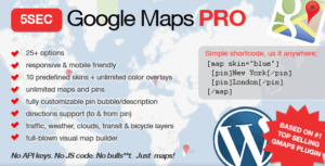
Effortlessly include highly customizable Google Maps on any site Based on 1 top selling Google

Super Interactive Maps is a fully featured WordPress Plugin integrated with Google Geochart API that

Hang on. We're loading...

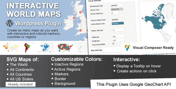
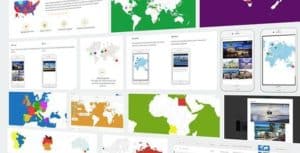
Interactive World Map is a Wordpress plugin to create as many maps as you want, with interactive and colored markers, continents, countries or regions.
(Check out the standalone non-wordpress version here)

Fully compatible with the brand new WordPress v.5

Show Different Regions

You will be able to show hundreds of different kinds of maps, already included:

  • A map of the entire world.
  • A continent or a sub-continent. (Africa, Europe, Americas, Asia, Oceania and all their sub-continents)
  • A country. (virtually all the countries in the world are included, featuring the most requested: USA, United Kingdom, Canada, France, Germany, Spain, Italy, Brazil, India, Australia…)
  • A country divided by its regions. *
  • A state in the United States.
  • The United States divided by metropolitan areas.
  • A state in the United States divided by metropolitan areas.

Color Regions or add Markers

You can add active colored regions to the map, and display them in 2 different ways:

  • As Regions – It will color the whole region, for example a continent, subcontinent, a country, a country province, or a US state.
  • As Markers -It will display a colored bubble in the chosen regions, that can be a city, a state or a country.


See the DEMO to see how they interact!

Add Interactivity

You can add interactivity to the active regions:

  • A Tooltip- A tooltip will be displayed by default on hover with the information you provide.
  • An Action ? You can set up diferent kinds of action for when the user clicks in an active area. You can make a new URL open, or simply display a message. Advanced users will be able to create their own Javascript functions for customized actions, like opening information with a lightbox effect.

Customizable

You will be able to costumize the visual of your maps:

  • Background color;
  • Box border width and color;
  • Inactive regions color;
  • Individual colors for each active region;
  • Markers size;
  • Width and Height of the map;

Add the Maps anywhere on your website

You can use a shortcode to include the maps in posts, pages and even in sidebar widgets! You can also add the maps to your template, with a simple php function.

Responsive

If no width is specified it will load with the maximum width available in the container div. For example, it will load and adapt with different sizes for phones/ipads/laptops. However, after loaded it will not change size if you resize the window.

Since version 1.4 the plugin includes an option to make the maps fully Responsive. This will use jQuery to check if the window size changed and will redraw the map with the new available space. RESPONSIVE INTERACTIVE MAP EXAMPLE

Cross device and browser compatible

The maps are built in SVG, no flash is used and therefore they will display in Mac products.

CSS Hacks made easy

There a few features that the Google Geochart API doesn’t provide by default, but the plugin provides a ‘Custom CSS Generator’ to help implement some features like hover colour change effect, implement font icons as markers, change border colour, among others.

 Example of map using font icons from fontAwesome toolkit using some CSS tricks, available from version 1.7.3 released January 2016. Learn more about this technique.

Where to use it?

This plugin is perfect for:

  • Travel Websites – Create maps to display destinations and link to pages about a specific location
  • Traveler Website – Display a map with destinations/countries visited
  • Multinational Companies – Create maps of the cities/countries where they operate
  • Small Companies – Show the location of the business in a country map
  • NGO’s – Create maps of NGO projects around the world
  • Infographics – Display simple to read maps with various information
  • And much more other applications! Be creative!

Including:

  • Divi – by ElegantThemes
  • Avada
  • X Theme

Creative Examples

Custom USA Elections Map

Related item support tickets

Here are public support requests that are related to this item. If you cannot find what you need, please hit Report error button.
No related request was found.

Why choosing GPL Coffee?

How to download interactive world maps 2.5 The Responsive Maps Plugin

How to install interactive world maps 2.5 The Responsive Maps Plugin

After click Download button above, you’ll get codecanyon-interactive-world-maps-2.5.zip. Normally, you have to unzip codecanyon-interactive-world-maps-2.5.zip, then find the installable sub-zip to upload to your server or your Wordpress admin area. But there are times you don’t have to do that if there is no sub-zip files inside codecanyon-interactive-world-maps-2.5.zip, e.g there is only one folder inside codecanyon-interactive-world-maps-2.5.zip.

Black Friday ultimate deal

Enjoy up to 50% off our packs.

(Discount is applied forever as long as the subscription is active)